

Shipping LTL freight to or from Missouri? Rates depend on your specific route, freight class, and how close your pickup or delivery point is to the nearest LTL terminal. Missouri runs two of the country’s biggest freight engines at opposite ends of the state — Kansas City’s rail network and St. Louis’s river port — connected by one of the only major toll-free highway systems left in the country. Here’s what actually affects your rate.
LTL trucking regulations in Missouri
Standard interstate trucking limits apply in Missouri: 80,000 lbs gross vehicle weight, 53 feet trailer length, 8.5 feet width, and 13.5 feet height. Most LTL shipments fall well within these limits — this mainly matters if your freight is unusually large or heavy.
Missouri’s real regulatory distinction is what it doesn’t have: a toll authority.
- Missouri has been completely toll-free since April 2024, when its last remaining toll crossing — the Lake of the Ozarks Community Bridge — paid off its construction debt and stopped collecting. Missouri voters actually rejected statewide toll-road proposals twice, in 1970 and 1992, and the state has funded its more than 33,000 miles of highway through fuel taxes and vehicle fees ever since.
- For LTL freight, that means no toll surcharges, no separate turnpike permitting, and no dimension caps layered on top of standard MoDOT rules anywhere you route through Missouri — a genuine cost and routing simplification compared to states with an active turnpike authority.
Missouri’s toll-free status is public record:
Are There Still Toll Roads in the State of Missouri? — Gigafact →
What affects your Missouri LTL rate
- Freight class — density, handling, and liability determine your NMFC class, the single biggest factor in your rate. See our freight class guide.
- Distance — Missouri’s carrier density is concentrated around Kansas City and St. Louis, at opposite ends of the state; coverage thins out in between and toward the south.
- Terminal proximity — pickup or delivery points near Kansas City, St. Louis, or Springfield typically see the most carrier options and fastest transit; the rural Bootheel region in the southeast sees meaningfully fewer options.
- Accessorials — liftgate, residential, or inside delivery add to the base rate, same as anywhere else.
Did you know?From 6 real Missouri lanes and 30 quotes
-
4× the cost per mile
The shorter haul cost far more per mile
A 2,400 lb shipment moving 511 miles (Springfield, MO to Chicago, IL) had a lowest quote of $694, or $1.36 a mile. A 350 lb shipment moving 966 miles (Kirksville, MO to Cairo, GA) had a lowest quote of $374, or $0.39 a mile.
-
$182 to arrive one day sooner
Saving a day is not free
On Harrisonville, MO to Sacramento, CA (1,763 miles, 820 lb), the cheapest quote at $811 took 5 days. The fastest, at 4 days, cost $993. On Kirksville, MO to Cairo, GA, 2-day delivery cost $503 against $374 for 3 days.
-
5 carriers had the lowest quote
Five different carriers won six Missouri lanes
Central Transport had the lowest quote on two lanes. AAA Cooper, ABF Freight, Dohrn, and Warp each had the lowest quote on one lane. Across the lowest quotes on every lane, 15 different carriers appeared.
-
$709 from lowest to fifth-lowest
Same shipment, quotes $709 apart
For 2,400 lb from Springfield, MO to Chicago, IL (511 miles), the lowest quote was $694 and the fifth-lowest was $1,403, a 102% gap.

Regional carrier coverage across Missouri
Missouri’s freight geography is genuinely bipolar — two major metro engines nearly 250 miles apart, connected by I-70, with real coverage differences everywhere else:
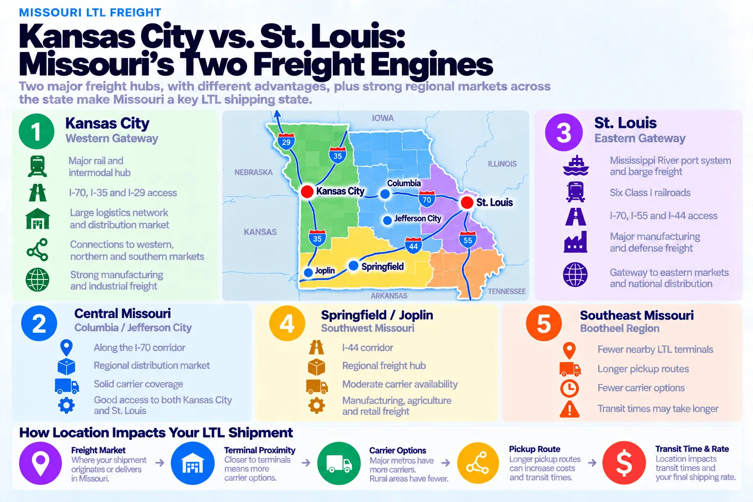
- Kansas City Metro — the deepest carrier network in the state, built on one of the busiest rail hubs in the country and strong I-70/I-29/I-35 access.
- St. Louis Metro — an equally strong second market, anchored by a major Mississippi River port system and Boeing’s defense manufacturing footprint, with I-70/I-55/I-44 access.
- Central Missouri (Columbia & Jefferson City) — solid secondary coverage along the I-70 corridor connecting the two major metros.
- Southwest Missouri (Springfield & Joplin) — a real regional hub along I-44, with moderate carrier density.
- Southeast Missouri & the Bootheel — the thinnest coverage in the state: fewer terminals, longer pickup routes, and a region that also sits inside the New Madrid Seismic Zone.
Weather and transit reliability
Missouri sits at the northern edge of Tornado Alley and the western edge of Dixie Alley, so spring and early summer bring real tornado and severe thunderstorm risk statewide, with large hail common. Winter adds routine snow and ice, heavier in the north. Missouri also carries a genuinely distinctive long-tail risk most states don’t: the New Madrid Seismic Zone, centered in the southeastern Bootheel, produced the largest earthquakes in recorded US history in 1811-1812 and is still an active hazard today — the USGS puts the odds of a magnitude 6.0+ event at 25-40% over the next 50 years. Much of the region’s highway and railroad bridge infrastructure over the Mississippi River predates modern seismic codes, which is why federal and state agencies actively plan around it as a real supply-chain risk, not just a historical curiosity.
Sample Missouri LTL rates by route
Real quotes pulled from our platform for six different Missouri lanes — same process, different carriers each time, spanning a huge range of weights and distances. Rates shift with capacity and fuel costs, so treat these as a snapshot rather than a guarantee for your shipment; get an instant quote for your exact route.
Real quotes by route
Snapshot taken over recent weeks — carriers and pricing change daily.
| Carrier | Service | Transit | Price |
|---|---|---|---|
| Warp | STD | 3 days | $435.10 |
| Estes | STD | 2 days | $546.92 |
| Forward Air | Standard | 2 days | $566.52 |
| XPO | STD | 2 days | $591.74 |
| Roadrunner Freight | Standard Service | 4 days | $593.28 |
| Carrier | Service | Transit | Price |
|---|---|---|---|
| Central Transport | Standard | 3 days | $373.97 |
| Dayton Freight | STD | 2 days | $502.71 |
| Southeastern Freight Lines | Standard | 4 days | $516.77 |
| Estes | LTL Standard Transit | 2 days | $529.80 |
| TForce Freight | Standard | 3 days | $533.64 |
| Carrier | Service | Transit | Price |
|---|---|---|---|
| Central Transport | STD | 2 days | $354.64 |
| Forward Air | Standard | 4 days | $399.41 |
| TForce Freight | STD | 3 days | $419.64 |
| R+L Carriers | STD | 2 days | $424.59 |
| FedEx Freight Economy | Standard | 3 days | $442.53 |
| Carrier | Service | Transit | Price |
|---|---|---|---|
| ABF Freight | Standard | 5 days | $1,207.58 |
| Roadrunner Freight | Standard Service | 4 days | $1,223.25 |
| Forward Air | Standard | 4 days | $1,320.52 |
| TForce Freight | Standard | 4 days | $1,366.48 |
| FedEx Freight Economy | Standard | 6 days | $1,746.04 |
| Carrier | Service | Transit | Price |
|---|---|---|---|
| Dohrn | STD | 5 days | $811.02 |
| XPO | Standard | 4 days | $993.19 |
| R+L Carriers | Standard | 5 days | $1,082.47 |
| Dayton Freight | STD | 5 days | $1,214.96 |
| Estes | LTL Standard Transit | 4 days | $1,219.91 |
| Carrier | Service | Transit | Price |
|---|---|---|---|
| AAA Cooper Transportation | Standard | 1 day | $693.89 |
| Central Transport | Standard | 1 day | $860.69 |
| ABF Freight | Standard | 3 days | $977.86 |
| Estes | LTL Standard Transit | 2 days | $1,046.20 |
| US Road | Standard | 2 days | $1,402.82 |
Rate, transit, and price-per-mile summary
Pulling the six lanes above together, one lane breaks away from the rest of the pack by a wide margin — and it’s the shortest, heaviest one in the data:
| Route | Distance | Weight | Price range | Transit range | Price per mile |
|---|---|---|---|---|---|
| Saint Louis, MO → Arlington, VA | 834 mi | 69 lb | $435–$593 | 2–4 days | $0.52–$0.71 |
| Kirksville, MO → Cairo, GA | 966 mi | 350 lb | $374–$534 | 2–4 days | $0.39–$0.55 |
| Acworth, GA → Saint Joseph, MO | 825 mi | 480 lb | $355–$443 | 2–4 days | $0.43–$0.54 |
| O’Fallon, MO → Seattle, WA | 2,051 mi | 800 lb | $1,208–$1,746 | 4–6 days | $0.59–$0.85 |
| Harrisonville, MO → Sacramento, CA | 1,763 mi | 820 lb | $811–$1,220 | 4–5 days | $0.46–$0.69 |
| Springfield, MO → Chicago, IL | 511 mi | 2,400 lb | $694–$1,403 | 1–3 days | $1.36–$2.75 |
Springfield to Chicago is the standout: at just 511 miles — the shortest lane in this data by a wide margin — it’s also the heaviest at 2,400 lbs, and that combination pushes it to $1.36-$2.75 per mile, roughly double every other lane here. The five remaining lanes tell a more ordinary story, clustering between $0.39 and $0.85 per mile regardless of direction. Notably, the longest haul in the data — O’Fallon to Seattle at 2,051 miles — isn’t the cheapest per mile; at 800 lbs it’s also one of the heavier shipments, and it lands at the high end of that ordinary range ($0.59-$0.85) rather than benefiting from a pure long-haul discount. The lightest lane, a 69 lb shipment from St. Louis to Arlington, actually prices in the middle of the pack — a reminder that for LTL, weight and distance interact rather than either one working in isolation.
Major shipping hubs in Missouri
Missouri’s carrier terminal network is concentrated around a handful of metro areas, which generally means faster pickup windows and more carrier options the closer you are to one of these:
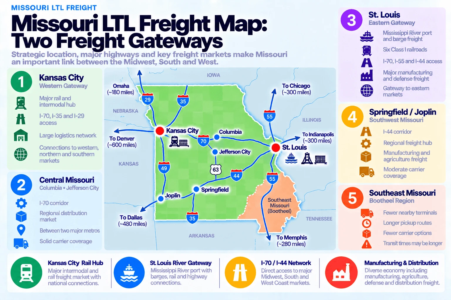
- Kansas City — one of the largest rail hubs in the country by tonnage, moving an estimated 250+ million tons of freight a year through a rail and logistics sector that supports over 30,000 regional jobs. BNSF’s Argentine Yard, one of North America’s largest classification yards, anchors the city’s Logistics Park Kansas City intermodal complex.
- St. Louis — home to a genuine trimodal freight system: a Mississippi River port network, direct access to six Class I railroads, and Boeing’s primary US tactical fighter manufacturing hub, producing the F-15EX, T-7A, and MQ-25.
- Springfield — southwest Missouri’s regional hub, with solid I-44 access.
- Columbia & Jefferson City — central Missouri’s secondary market along I-70, between the two major metros.
- Stockton — a genuinely unique niche hub: home to Hammons Products, the world’s largest black walnut processor, which collects raw walnuts from 220 stations across a 12-state area and ships shelled nutmeats out to food manufacturers nationwide.
Highway corridors serving Missouri
I-70 is Missouri’s primary freight spine, running the full width of the state from Kansas City through Columbia and Jefferson City to St. Louis. I-44 runs from St. Louis southwest through Springfield toward Joplin and Oklahoma, largely tracing old Route 66. I-55 heads south from St. Louis through the Bootheel toward Memphis. I-29 runs north from Kansas City toward Iowa and Omaha. I-35 runs south from Kansas City toward Oklahoma. Nearly every long-haul route crossing the central US touches Missouri somewhere along I-70 or I-44.
Why St. Louis is a trimodal freight powerhouse
The numbers here are genuinely striking: the St. Louis regional port system covers only about 8% of the Mississippi River’s 855 navigable miles, yet it carries a full one-third of all freight moving on the river. Fifteen barge-transfer facilities give the region capacity to handle up to 150 barges a day — the highest concentration anywhere on the Mississippi — and six Class I railroads reach the region from both banks of the river, making St. Louis one of the few places in the country where barge, rail, and interstate highway freight genuinely converge. On top of that river-and-rail base, Boeing just locked in a $131.2 billion contract in August 2026 to keep building F-15EX fighters in St. Louis through 2037, and is doubling production from one jet a month to two by 2027 — a real, current sign of how much manufacturing freight still moves through the region alongside its barge and rail cargo.
What Missouri shippers move
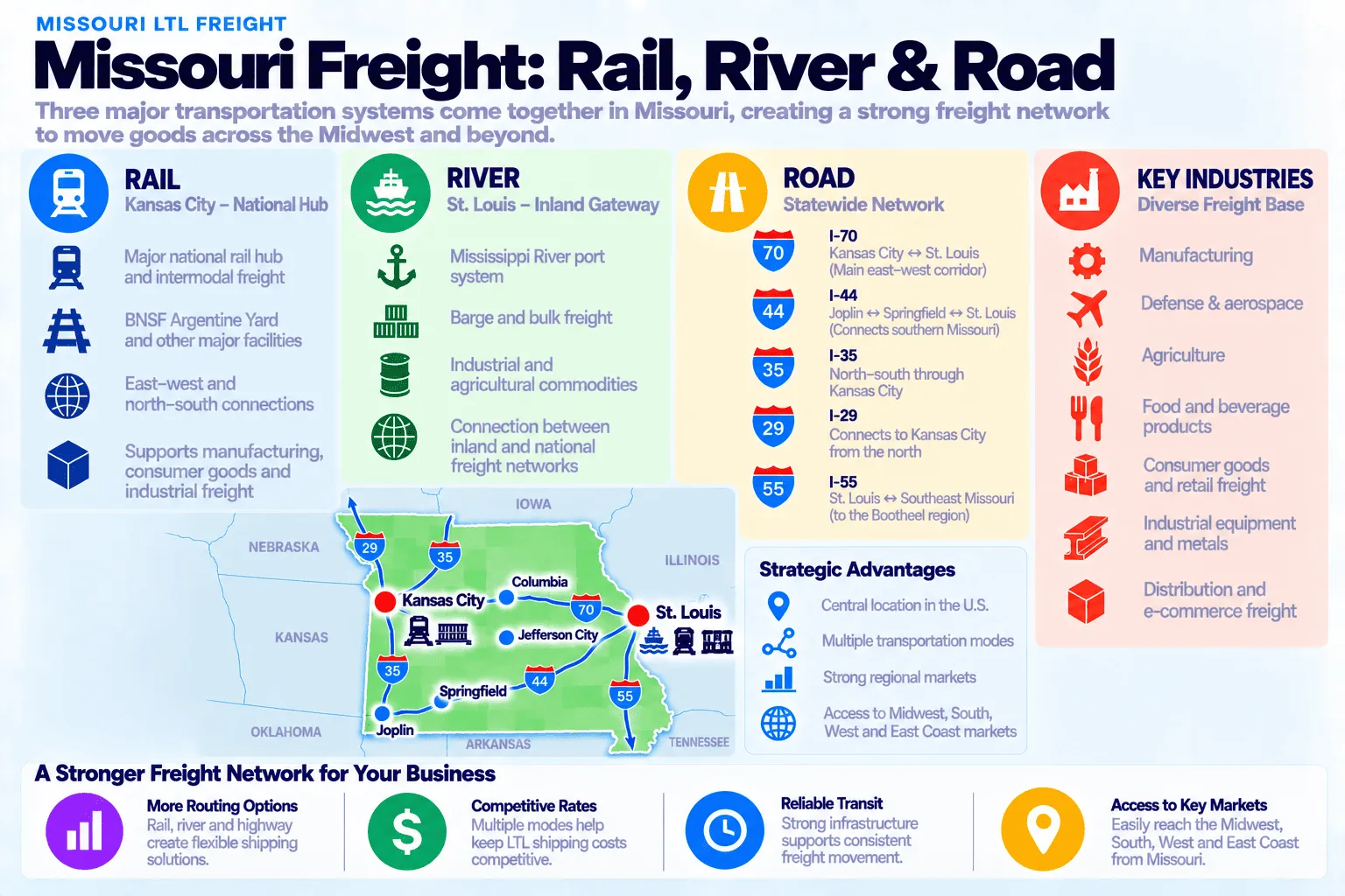
Missouri’s freight mix is anchored by transportation infrastructure as much as any single industry. Kansas City’s rail network alone generates an estimated $10 billion in annual economic impact and moves freight for industries across the entire central US, not just Missouri. St. Louis adds a genuine river-and-defense pairing: its port system carries a third of all Mississippi River freight, while Boeing’s F-15EX, T-7A, and MQ-25 production lines generate a steady stream of oversized, high-value aerospace and defense freight found in few other states. Agriculture remains a real pillar too — Missouri is a major soybean, corn, and cattle producer — with a genuinely distinctive niche: Stockton’s Hammons Products is the world’s largest black walnut processor, pulling raw walnuts in from a 12-state collection network and shipping shelled nutmeats out to food manufacturers nationwide.
Get a Missouri LTL quote
Compare live rates from vetted carriers serving Missouri.
Get an LTL quote →Missouri LTL freight: frequently asked questions
How much does LTL shipping cost to or from Missouri?
It depends heavily on distance and weight. Real Missouri lanes in our data ranged from about $355 for a moderate regional shipment out of Georgia up to $1,746 for a long-haul shipment to Seattle — and the priciest lane per mile was actually the shortest one, a 2,400 lb shipment covering just 511 miles to Chicago, since minimum handling and weight charges apply regardless of distance. Get an instant quote for your exact shipment.
Does Missouri have toll roads that affect LTL shipping?
No. Missouri has been completely toll-free since April 2024, when its last toll crossing paid off its construction debt. That means no toll surcharges and no separate turnpike permitting anywhere you route through the state — a genuine simplification compared to states with an active turnpike authority.
Why is Kansas City important for Missouri freight?
Kansas City is one of the largest rail hubs in the country by tonnage, moving an estimated 250+ million tons of freight a year and supporting over 30,000 regional jobs. BNSF’s Argentine Yard, one of North America’s largest rail classification yards, anchors the city’s intermodal freight network.
Which carriers serve Missouri?
Most major national LTL carriers serve Missouri, with the deepest coverage around Kansas City and St. Louis — availability and pricing vary by exact route, and rural southeast Missouri sees noticeably fewer options.
Is LTL service the same everywhere in Missouri?
No. Kansas City and St. Louis both have strong, roughly comparable carrier coverage, with solid secondary coverage in Springfield and along the I-70 corridor between them. The rural Bootheel region in the southeast sees meaningfully fewer carrier options and longer transit times.
Does the New Madrid Seismic Zone affect shipping in Missouri?
Not day-to-day, but it’s a real long-term risk factor specific to southeastern Missouri. The New Madrid Seismic Zone produced the largest earthquakes in US history in 1811-1812, and the USGS estimates a 25-40% chance of a magnitude 6.0+ event in the next 50 years — a risk that federal and state agencies actively plan around given how much older Mississippi River bridge infrastructure sits in the zone.